
Today we are going to start the quest to find Kama Koia – the farm or the house built by my grandparents in 1926 of the same name, or just the site of the house since my Aunt Sue has warned that it had been demolished by the time she came here in 1962. Colin has worked out GPS coordinates by freezing a frame of his video of Sylvia showing us a Land registry map and my grandmother’s sketch map – it’s schematic but has useful relationships in miles from KK to neighbour’s, the Elgon Club and Kitale.
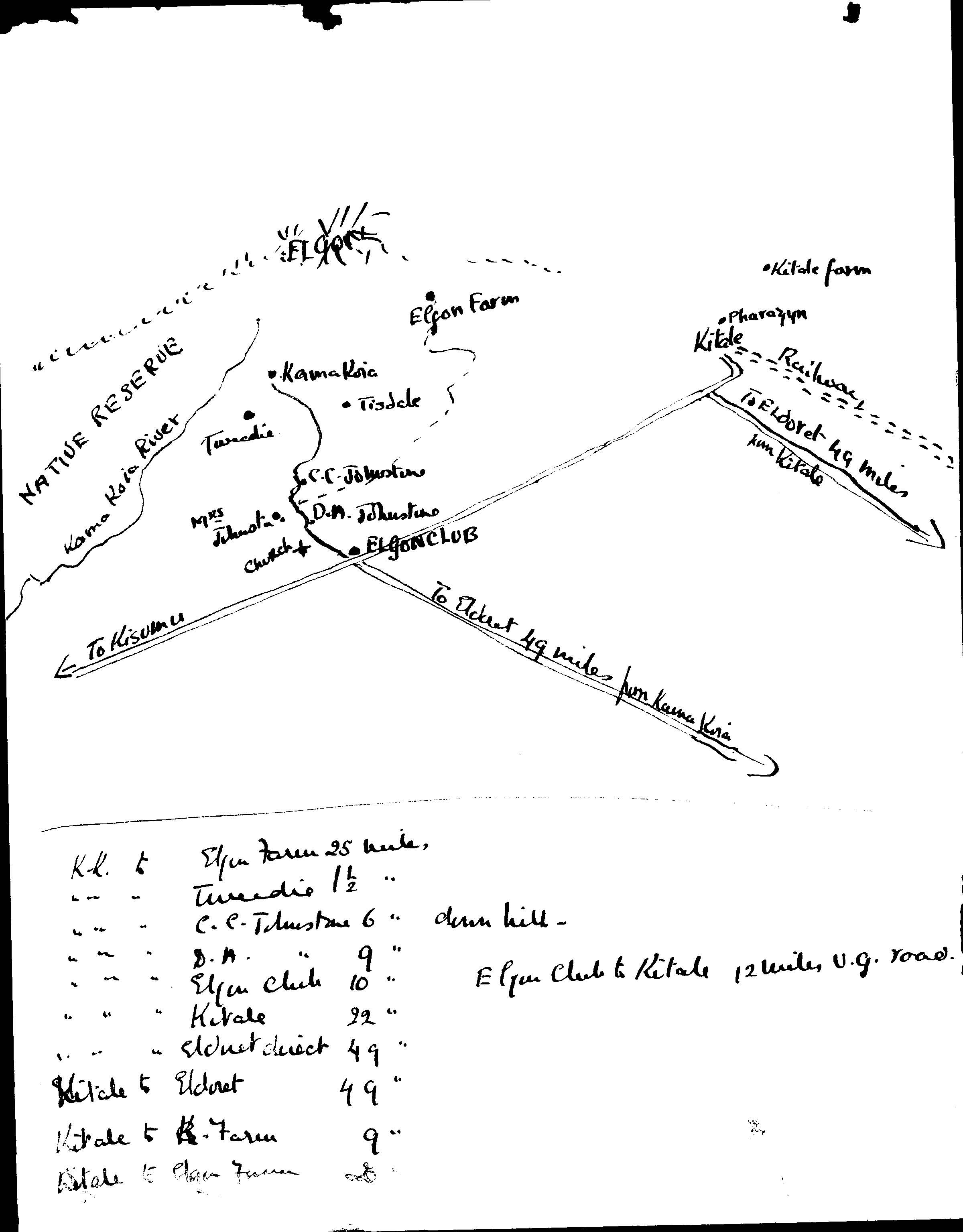
If we get to the right area maybe we’ll recognise something from some topographical clues of where KK house and farm which my grandmother described them to her father in his letters; or maybe someone will recognise the photographs of the house and farm and from my Aunt Sue’s visit to this area in 1962.
The Clues
1. Fred Chater Jack bought Kama Koia Farm from Gordon Hewitt in 1925. The land as bounded between the Kama Koia River and the Machewa River.
2. Gordon Hewitt split his farm and sold the higher part to the Jacks and the lower part to another family, the Tweedies – Emilie May wrote January 1927: ‘The Tweedies house is a wooden one built by Gordon Hewitt and they have added to it in stone for the users and verandah. Our house will be 1 1/4 miles from theirs.’
3. A description: ‘Our house is not on land near the Kama Koia Farm which Fred is running with Arnold – but we have take a piece of land in the farm for house & garden. This will be our own and if the farm is sold [it] will be sold separately… [it] is approx. 6750 ft.’ Confusingly, both the house and farm were called Kama Koia.
4. The house is on a hill and stands five steps up from enough flat land for a lawn, herbaceous border, apple orchard and vegetable patch. There is no view of either river from the house. To the north, the view from the dining room is of Mt, Elgon. To the south, from the drawing room, the view is of the Nandi escarpment as a blueish haze some 60 km away.
5. A Swiss man, Mr. Gantz, bought Kama Koia Farm on the slopes of Mt Elgon in 1938 – a parcel of land numbered 6698 in the Land Registry – the same numbering system is used today for land registry. Each numbered area was/is 500 acres. Plot 6698 was likely to be KK (the company) and not the house, because Sylvia warned that there was no house on the land her father bought nor were there any sign of flowers or a horticultural farm with orchard and vegetables.
6. A photo of the land marked ‘Gantz’ with number 6698 of the Land Registry Map of the district that Gantz’s daughter, Sylvia Davidson, showed us. My finger pointing it out to make it even more clear.
Sylvia’s parents sound really interesting, I would very much have liked to meet them. He was a geologist working on an oil rig near Guryev for Shell Petroleum before the Russian Revolution. Guryev is on the River Ural before it discharges into the top of the Caspian Sea. He had time off every two months. Her mother, also Swiss, lived in Guryev where she had her children. In order to see her husband she would ride a donkey out to the rig. He had to flee Russia in 1918 when Russia descended into Civil War and lost a great deal of money when the Rouble collapsed. This would be unimaginable for today’s pampered oil workers for international companies with their well paid secure jobs and pay in their home country.
-––
Armed with the GPS coordinates, we set off down the fast-slow shambles of the Kitale-Kisumu road. The fast bit down the new hard top road laid by the Chinese; the slow bit along dirt track beside the roadworks with impatient Mutatu (buses) weaving in from tracks that don’t exist putting bumping red dust everywhere. The new yellow road making equipments and road rollers look and efficient high above us. Modern and mechanised – a different century to the Kenya until now. In that Kenya, road repair in the Nairobi outskirts and near Nakuru involved gangs of young people demanding payment from cars driving over ‘their’ rock-filled pothole.
Dust hangs on the barbed wire fencing of Kitale Airport and removes the green from the bushes. Small, one-story breeze-block buildings contain the hopes and pre-occupations of the Luhya tribe who live here: Schools in abundance – The Repentance & Restoration Kingdom Church, Family Glory Church, The Blessed Meals Church; Schools – Kiminini Girls High School, Muungano High School Emmuels’s Private School (‘Mould a child into a responsible citizen’); two hospitals, finance and technology – Mama Nancy Investment, Mutayi Investments, The Big Vision Shop on one side of the road and The Second Big Vision Shop on the other and STV.
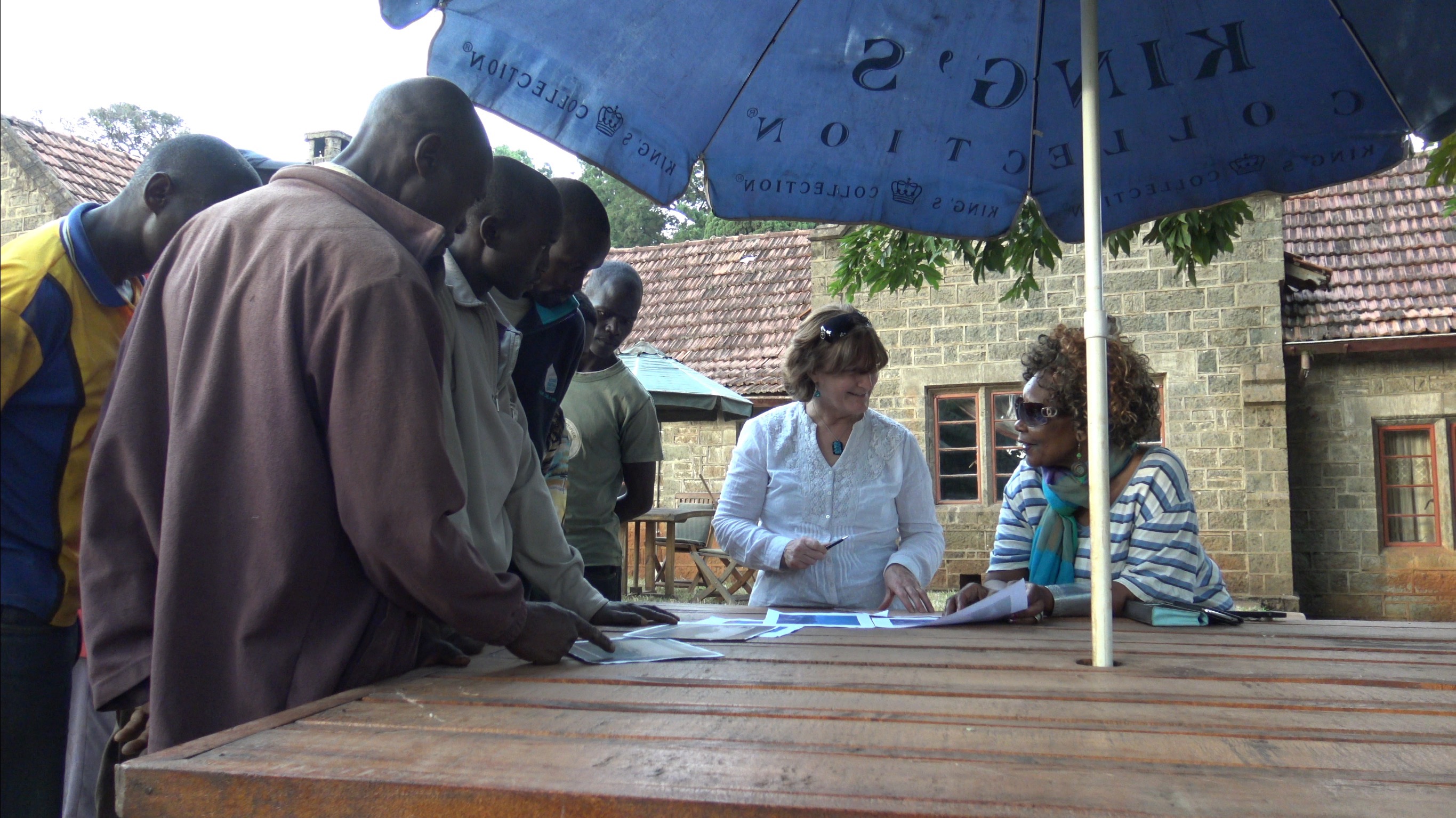
After 22 mud-eating miles, the distance given on Emilie may’s sketch map is always in miles, we look for a crossroads, a church or The settler’s Elgon Club in the straggling russet-coloured market in Kiminini – get the stress point right and the name is sayable – but either the new road or the market has obscured them all and we have left Miminini when a red well-graded Murram road comes up on our right, We consult an old man of indeterminate age and wheezy chest, he knows the Elgon Club – “Go back 5 kms,” he says – but the persuasion from the GPS wins. The checkered flag for the Gantz farm waves a few miles up this road – the Elgon Club can wait, we go right.
After 4 km the GPS indicates the Gantz farm is on the left. A plantation of young Eucalyptus finishes beside a very small overgrown track – no cars have gone down this for a while. High grass grows in the middle and right of the cart wide tracks. The land is flat and low lying beneath higher unfarmed land. Of course we drive in. The grass tickles the underneath of our car like a feather dust and Robert looks nervous, there’s no obvious place to turn if the road deteriorates. After 3/4 km we come to a mud hut, and two men: one old and one young. Robert calls in greeting and asks about old Mzungu (foreigner) houses in the area. “The young man knows of three,” he translates, “Can he come and show us?”
I clear the back seat beside me to find space. The young man has a strong physique, a very long strong neck and a broad, handsome face with a strong equiline nose. His skin is black as satin. He looks around the car and we study each other. He has a wide lovely smile and white even teeth. This man does not look like anyone I’ve met in Kenya yet. He tells me, in English, that his name is John. I ask about his family and he replies in Swahili.
“He has no education and no English,” translates Robert. “He is Turkana, 23 years old and works for the old man. He has no sisters or brothers. His parents were killed and he move here two years ago.”
The tribal conflict over water in Turkana was bitter enough without the recent oil find adding to the mix. So many have been displaced and so many lives lost. John asks Robert questions about us, Robert, the car, current news. He is interested and he is intelligent. There’s a real niceness and straightforward manner to this man. I feel so sorry for the hand he’s been given. Life without an education is hard enough in modern Kenya with only 1:10 with employment, but without a family to help it is a disaster. Even getting married will be difficult.
John directs us back along the main road and then left to the first colonial house. It’s also in the valley and away from the land we think is KK – house or farm, but it’s definitely an old settler bungalow of stone in a large compound. “An old Mzungu called Prisilla lived here,” said Robert translating. It is derelict but was upgraded with 1960’s steel frame windows, a tiled roof and relatively new whitewash. At some time it was wired into the grid for electricity. The new Kenyan owner has built his house of corrugated iron to the side. Upkeep of the bungalow would be too expensive and the style uncomfortable perhaps.
We go onto the next house on the other side of the Gantz area and at a five-way junction. The short rocky road tests the saloon car. The house was post Second World War, stone built in the settler style. It is probably a rebuild of an older settler house but the position is not right – it’s on the road, not set back and is in the valley. With great difficulty, removing stones out of the road so the low slung car can turn in eight points, we go on to the third house.
The road climbs the ridge above the Gantz area to the north and towards the Kama Koia River. Brilliant! This is the right direction.
After 3 or 4 kilometres we come to a gateway and a long avenue of trees climbing the hill to the north. Judging from the line of the avenue, this was a newer road as ‘our’ road bisected the avenue. The trees are old, at least 80 years old as an estimate. I know that Emilie May had an avenue planted, she called them The Coronation Trees to mark the date they went in – but then she wrote that other settlers had avenues too. We go through a gate into a compound with a huge magenta bougainvillea, a large pyramidical Cyprus, an old casuarina. There are views on all sides and excellent farmed land. We’ve been so excited with the discoveries that we find ourselves at a private farm house with SUVs parked. Nothing doing but to get out and excuse our trespass!
We park beside a settler-style bungalow in post-World War Two style. A lady is sat at an outside table with a man in his sixties. Six young men looking like farm workers stand nearby leaning on some outhouses. “Come in, come in, we don’t know the word trespass in Africa. All visitors bring blessings.” She said in an Eartha Kitt voice, motioning us through the small garden gate. She stays seated and the man came forward. ‘My PA, Charles,’ she says. The lady is very well dressed – a large worked silver bracelet on her left arm, the latest smart phone in her right hand and a very expensive large gold handbag lies on the bare earth, folded as it fell. Her shoes are lovely, in many colours with a small heel. Long earrings with a turquoise bead and stone with an inset carved swirl completed the waved coiffured hair. It is now late afternoon and cooler so warmth is achieved by a striped cardigan with a beautiful scarf melding turquoise, purple, light blue against a cream background round her neck. “I’m just a simple farmer,” she says. Yea, Right!
E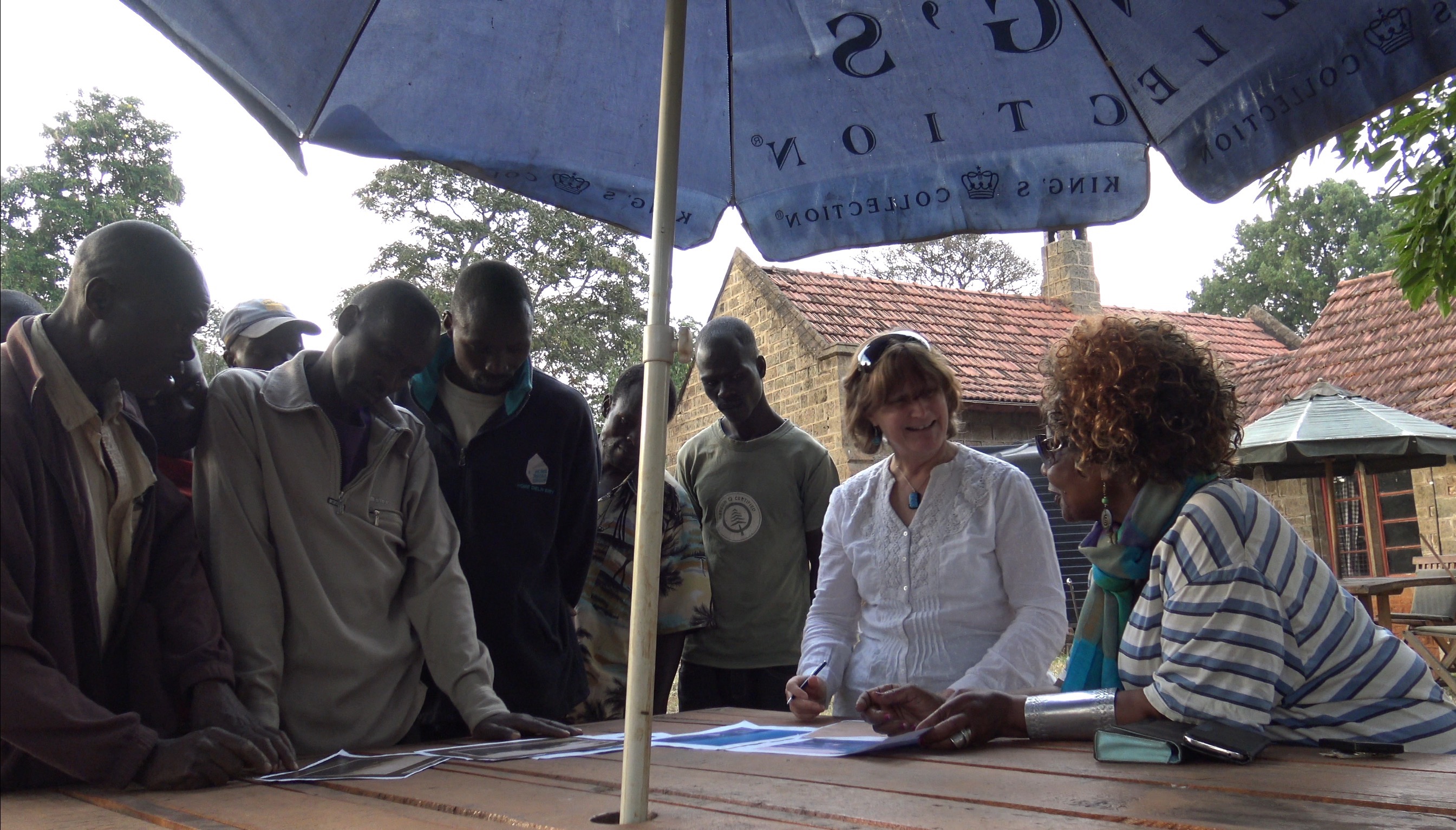
 She tells us that the farm, plots nos. 5368 & 6932 on the land registry map, is called Machewa Farm after river beside it and that the house has a foundation stone dated 1946. We can see from the Land Registry Map that it borders on the Gantz farm of Kama Koia.
Could this must be KK land? It was bounded by the Kama Koia River but maybe not the Gantz farmland. We exchange contact numbers and she promises to give me the information of the previous owners. I look her up on the net. The lady was formerly the UN Ambassador for Kenya, the head of Kenyan association of NGOs, a campaigner for women’s rights and a former Miss Kenya. It would be really amazing if it was also the former site of my grandmother’s house. She would approve of this lady.
We arrive late back at the Karibuni Lodge at 20:45. Ibrahim has waited for us with our meal. He really is a great cook and this place has been a pleasure to stay in.
Today we excluded a lot of potential sites for KK house or farm. Tomorrow we will resume the quest – we’ll find the crossroads at Kiminini and look for the remains of the (overgrown) Elgon Club and the current church (either St John’s Church or built on the site of it at), and then follow Emilie May’s sketch map past the Johnstones’ three farms and on to the Jack acreage. Maybe tomorrow we’ll find KK or the site).